Climate change driven by global warming is causing frequent large-scale floods, not only in Japan, but across the globe. This situation means that disaster risk reduction measures in Japan have reached a major turning point. The field is about to enter a more practical, advanced phase of efforts to respond to meteorological disasters in the form of typhoons, linear rainbands, and the localized downpours of torrential rain over a short period–known as guerrilla rainstorms. In addition to more accurate forecasting, these responses include flood control plans based on the assumption of flooding. At the same time, appropriate risk communication that conveys uncertainties is also required.
Special Feature 1 – Recommendations for Scientific Disaster Risk Reduction Japan’s disaster risk reduction at a turning point: Responding to climate change
composition by Rie Iizuka
illustration by Koji Kominato

Eiichi Nakakita
Director, Disaster Prevention Research Institute (DPRI), Kyoto University
Born in Osaka City in 1959. Graduated from the Department of Civil Engineering at Kyoto University's Faculty of Engineering in 1983. In 1985, he successfully completed a master's program at the Department of Civil Engineering at Kyoto University's Graduate School of Engineering. In November 1990, he obtained a Ph.D. in engineering from Kyoto University. In 2004, he was appointed professor at the DPRI's Water Resources Research Center, and in April 2005 became professor in the Research Section of Hydrometeorological Disasters within the DPRI's Research Division of Atmospheric and Hydrospheric Disasters. He has held his current post since 2021. He has previously also held posts as a visiting assistant professor at the University of Iowa in the U.S., visiting research professor at the National University of Singapore, and visiting professor at Malaysia's Universiti Teknologi MARA. In addition, he has served on various committees, including chairing the Committee on Utilizing Weather Radar into River Management established by the Kinki Regional Development Bureau, Ministry of Land, Infrastructure, Transport and Tourism (MLIT).
Disaster risk reduction involves considering how to prepare in order to protect ourselves from a variety of disasters, including flooding and rivers overflowing due to heavy rain, as well as high waves, earthquakes, and volcanic eruptions. The saying “He who controls the water controls the people” dates back to ancient China, and the government’s disaster risk reduction efforts have primarily focused on flood control. In addition, the impacts of global warming have led in recent years to more frequent meteorological disasters, in the form of major typhoons on an unprecedented scale, linear rainbands, and guerrilla rainstorms. The number of occasions on which rivers exceed their flood danger water level has seen a dramatic increase, while the value of flood damage in 2019 was the highest since records began in 1961. This situation means that disaster risk reduction efforts today face two paradigm shifts, broadly speaking. The first is the approach to flood control plans.
River basin management also based on the assumption of floods
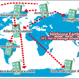
Since the Meiji era (1868-1912), flood control plans have sought to ensure that people can live near rivers and embankments by preventing rivers from overflowing. As urbanization has progressed, flood control measures in cities have centered on such efforts as the development of retention basins to ensure that rainwater is not discharged into rivers. However, with rainfall now rising, the need to amend this approach is emerging (Figure 1). There has been a shift in policy direction in favor of an approach called river basin management, which involves environmental enhancements throughout a river basin to protect lives and property. Rivers nationwide will require improvements and, depending on the location and the extent of rainfall, some degree of overspill from rivers may be tolerated, with homes relocated to sites further from the rivers if necessary.
| Region | 2°C rise | 4°C rise | |
| short time duration | |||
| Northern and southern Hokkaido | 1.15 | 1.4 | 1.5 |
|---|---|---|---|
| Northwestern Kyushu | 1.1 | 1.4 | 1.5 |
| Other regions (including Okinawa) | 1.1 | 1.2 | 1.3 |
Figure 1. Rate of change in total rainfall for flood control planning to cope with global warmingThe rainfall assumptions differ according to the extent of global warming progression. There is a 1.5 times increase in the case of a 4°C rise within a short time, starkly demonstrating the need to revise conventional plans.
The second major shift involves numerical decisions across the country about what level of heavy rain should be assumed in planning for flood control, using forecasts of future climate change as basic information in flood control plans.
To start with, flood control plans are prepared on the basis of standards referred to as “design rainfall” and “design floods.” These two standards have until now been set using past records and observation data, but due to the increased accuracy of computer forecasting of future weather in recent years, scientific climate change projections have come to be regarded as trustworthy. Incidentally, the database for Policy Decision making for Future climate change (d4PDF) was developed in Japan as a database on a global scale capable of estimating climate change scenarios in the event of future rises in average temperature of 2°C and 4°C, based on more than half a century of observation experiments.
- * A hydrograph (graph showing changes in flow rate over time) for flooding that serves as the target for measures.
Plans are being put in place regarding what should be done within the next 20-30 years, and the development plans for a number of Class A rivers —— specifically, the Kuma River in Kumamoto Prefecture; the Abukuma River, which flows through Fukushima and Miyagi prefectures; the Tokachi River in Hokkaido; and the Kumano River in the Shingu River system, which flows through the prefectures of Mie, Nara, and Wakayama —— have already been revised to address global warming. Similar responses for other rivers will likely be introduced progressively in due course.
Hitherto unprecedented meteorological disasters
It is envisaged that global warming will cause a steady stream of hitherto unprecedented meteorological disasters. The volume of rainfall during typhoons has seen a 10% increase compared with the situation 40 years ago, while the downpours frequently experienced in West Japan during the rainy season have become increasingly common in Northeast Japan (Tohoku), too. By the end of this century, even Hokkaido seems set to see rainy season downpours.
Typhoons, rainy season downpours, and guerrilla rainstorms differ in terms of the area over which the rain falls. In a typhoon, the rain falls over an extensive area, with enough heavy rain to cover the approximately 16,000 km2 basin of the Tone River, Japan’s largest river, while rainy season downpours are characterized by very long, narrow clouds across a distance of 100-200 km.
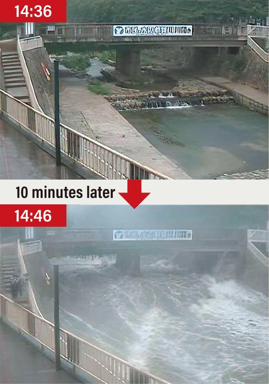
Guerrilla rainstorms, on the other hand, are sudden deluges of torrential rain confined to a very limited area, and can even cause loss of life. On July 28, 2008, five people, including three children, died when a guerrilla rainstorm hit around 50 people enjoying a recreational space along the Toga River in the city of Kobe (Figure 2). On August 5 that year, a sudden rise in the water level swept away six workers undertaking construction work on the sewerage system at Zoshigaya in Tokyo; five of them lost their lives.
 Photographs courtesy of Kobe City
Figure 2. Flash flooding of the Toga River in KobeThis was the kind of river where children normally used to play in the water, but a sudden influx of water in the space of just 10 minutes resulted in the loss of five lives.
Many researchers have been involved in large-scale weather forecasting of typhoons and the like, but guerrilla rainstorms occur suddenly and grow within a short time, making them difficult to forecast. In addition, as a research field, weather forecasting on an extensive scale, like that involving typhoons, perhaps feels more dynamic. However, as the Toga River and Zoshigaya incidents show, guerrilla rainstorms can rob people of their lives quite suddenly, so I have come to feel strongly that this kind of disaster must not be omitted from the mission of disaster risk reduction.
Disasters caused by guerrilla rainstorms can also be caused by the cities themselves. Rain falling on a mountain peak is absorbed into the ground, but as one gets closer to urban areas, the rainwater flows into the sewage system; in the Toga River case, this rainwater flowed from the drains into the river all at once, causing a flash flood at the riverside recreation area further downstream. If there had been soil surfaces or no sewers, the flash flood might not have happened.
So, how do guerrilla rainstorms actually occur? Incidentally, the meteorological term for a guerrilla rainstorm is “localized heavy rainfall.” However, I prefer to use the expression guerrilla rainstorm, as it appropriately conveys the nuance that they strike without warning and cause catastrophic effects.
Detecting cumulonimbus clouds with the potential for torrential rain is difficult
The prevailing view is that guerrilla rainstorms are a meteorological phenomenon caused by a single cumulonimbus cloud (Figure 3). The life expectancy of a cumulonimbus cloud is just one hour, so they do not result in long periods of rain. When an influx of water vapor hits a mountain, it builds up, creating an ascending current; the water vapor then cools and forms cloud droplets. When lots of these cloud droplets gather, they form raindrops.
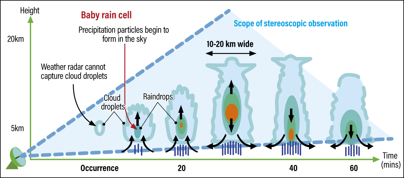
Figure 3. Development process of a cumulonimbus cloud bringing a guerrilla rainstormHumid air rises and forms cloud droplets. At ground level, the wind starts to blow. The air rises further and raindrops are formed from the cloud droplets. It is from about this stage that ordinary weather radar can detect them. At the baby rain cell stage, it is as though water continues to build up in a midair “bucket” supported by the ascending current. If we think of a guerrilla rainstorm as representing the point where the current can no longer support the weight, and the bucket tips over. What we are hoping to do with weather radar stereoscopic observation is to identify the point at which the water is starting to build up in the bucket.
The raindrops that gather in the sky eventually become heavy and fall all at once. This is torrential rain. In the evening this can cause a dry, cold wind to blow, because the cloud droplets fall along with air from an altitude of 5,000 m before the raindrops can fall. In addition, at altitudes above 5,000 m, the raindrops freeze and friction makes it easier for static electricity to build up, which is why thunderstorms sometimes occur. When looking at the damage caused by guerrilla rainstorms, we must focus not only on the heavy rainfall within a short period, but also on thunderstorms.
Numerical weather prediction is a form of weather forecasting that involves computer models simulating changes in the situation in the atmosphere, on land, or out on the ocean. This kind of weather prediction is used in forecasts of the next day’s weather and rain cloud movements. Numerical weather prediction uses a mesh (sectoral units based on dividing an area into smaller squares) delineated in units of 2 km.
Meanwhile, weather radar enables us to carefully observe the current status of the clouds in the sky. This technology is good for making observations such as, “It will rain here in five minutes.” However, it is not easy to detect the occurrence of cumulonimbus clouds with the potential to cause torrential rain, which would be effective in forecasting guerrilla rainstorms. While ordinary radar can observe raindrops with a diameter of a few millimeters that have formed in a cumulonimbus cloud, it cannot easily confirm the presence of cloud droplets, which only measure somewhere between 2-40 µm. Cloud droplets are thus a thousand times smaller than raindrops, but if we could quickly find signs of them within a cumulonimbus cloud, we would be able to issue guerrilla rainstorm forecasts along the lines of “There will be a downpour of more than 50 mm at this location in 20-30 minutes.”
Accordingly, we started working on observing the embryonic signs of a guerrilla rainstorm–baby rain cells. When a guerrilla rainstorm occurs, an ascending current swirls inside the initial cloud, forming a vortex. As this becomes more powerful, the cumulonimbus develops, but raindrops have already formed in the sky while the cloud is still small. These are baby rain cells. As they swirl around on the air current, these baby rain cells grow, increasing the likelihood of a guerrilla rainstorm. If we can spot baby rain cells early, we will be able to predict the occurrence of a guerrilla rainstorm 20-30 minutes beforehand.
When we examined how to observe baby rain cells, we found stereoscopic observation using weather radar to be effective. Ordinary weather radar detects rain at low altitudes by means of an antenna rotating at a low elevation angle close to horizontal, in order to measure the amount of rainfall onto the earth, but this kind of method is unable to observe the baby rain cells of guerrilla rainstorms occurring in the sky. However, MLIT had a weather radar conducting stereoscopic observation at the time of the Toga River accident, and when we checked the records, we were actually able to spot the formation of baby rain cells.
We then conducted various experiments and reported that stereoscopic observation using weather radar was effective in forecasting guerrilla rainstorms and other forms of localized torrential rain. As a result, the very latest radar, called XRAIN, which carries out stereoscopic observation, has been introduced at 39 sites nationwide. XRAIN has dramatically improved accuracy, as it can carry out observation using a 250 m mesh and observation data is transmitted within the national standard of 1 minute (Figure 4).
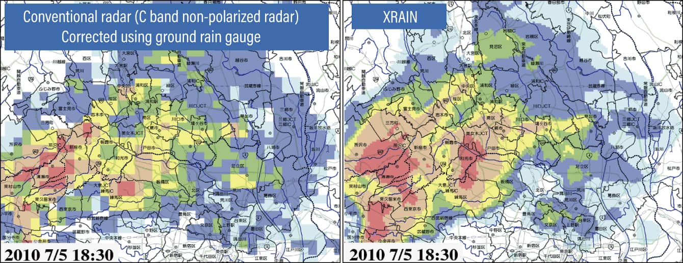 Figure courtesy of MLIT
Graphical representation of observation using conventional radar and XRAIN. It has become feasible to track individual cumulonimbus clouds.
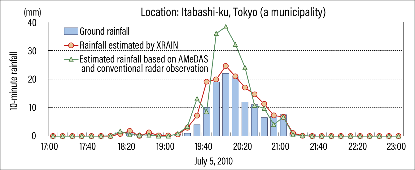 Figure courtesy of MLIT
The green line graph indicates the rainfall estimated by integrating rainfall at 10-minute intervals observed by AMeDAS and observation using conventional radar, while the bar chart indicates ground rainfall, and the red line graph indicates rainfall estimated using only XRAIN observation. We can see that XRAIN delivers a dramatic improvement in accuracy compared with conventional radar. On its website, MLIT provides XRAIN data about the sky above every municipality in Japan.
Figure 4. Comparison of conventional radar and XRAIN
We need to be prepared for higher frequency of meteorological disasters
The observation of guerrilla rainstorms is one example of preparing for meteorological disasters, which have hitherto tended to be overlooked. As I stated in the introduction, the impact of global warming is becoming increasingly apparent, as seen from such examples as the occurrence of rainy season downpours and landslides in East Japan, which never used to experience such phenomena. It is envisaged that the meteorological phenomena now occurring in West Japan will begin to occur in the Kanto and Tohoku regions in a few years, so soil researchers, meteorological researchers such as my team and I, and MLIT are involved in conducting region-specific surveys in an effort to revise disaster risk reduction standards. People also need to be prepared for the frequent occurrence of meteorological phenomena that have never been seen before.
Another key challenge right now is the question of how to communicate uncertainties. While research on earthquake and torrential rain predictions is progressing and findings are being published, I believe we urgently need to formulate standards how that information been communicated.
For example, it is believed that there is a 70-80% probability of a Nankai Trough Earthquake in the M8.0-9.0 class occurring within the next 30 years. As there is currently no established scientific technique for forecasting the timing, location, or scale of an earthquake, it is accepted that they are basically unpredictable, but we do know that the likelihood of its occurrence is very high.
From the perspective of risk management, we must not overlook the signs of an impending disaster. However, these are not definitive forecasts indicating when, where, and how much rain will fall without fail, or that an earthquake is certain to strike. Such forecasts will probably still be impossible 100 years from now. Hence, a philosophy is needed for handling and communicating scientific information on phenomena that are uncertain but highly probable at the same time.
At the DPRI, we devote our energies to conducting an interdisciplinary approach. In parallel with research into the prediction and mechanisms of such phenomena as climate change, earthquakes, tsunamis, and volcanic eruptions, it is necessary to consider the disaster risk reduction aspect, examining such matters as evacuation in the wake of a volcanic eruption or what happens if rain causes volcanic ash to flow down along with earth and sand. In such situations, we sometimes bring in experts in risk management or social psychology to work on the issues based on a cross-departmental collaboration. Having experienced such disasters as the Great Hanshin-Awaji Earthquake and the Great East Japan Earthquake, Japan is described as a disaster-prone country. We must continue engaging in wide-ranging discussions about how to protect the lives of the people who live in this country.
(Figures courtesy of Eiichi Nakakita)