As a disaster-prone country, Japan has some of the world’s most advanced systems for observing earthquakes, tsunami, and volcanic activity. In 2017, the National Research Institute for Earth Science and Disaster Resilience (NIED) launched a network called Monitoring of Waves on Land and Seafloor (MOWLAS), to integrate observation data from around 2,100 sites nationwide, covering land and sea, and facilitate the efficient sharing of this information with the Japan Meteorological Agency (JMA) and other relevant organizations (Figure 1). An Earthquake Early Warning alert is transmitted immediately after an earthquake strikes and information about the seismic intensity is sent about 90 seconds later. Japan is the only country in the world with this capability.
Special Feature 1 – Recommendations for Scientific Disaster Risk Reduction Advances in observation systems:
Monitoring of Waves on Land and Seafloor (MOWLAS) as the NIED observation network for earthquake, tsunami and volcano
composition by Takakazu Kawasaki
Shin Aoi
Director-General, Network Center for Earthquake, Tsunami and Volcano, National Research Institute for Earth Science and Disaster Resilience (NIED)
Graduated from the Faculty of Science at Kyoto University in 1991. In 1996, he earned his Ph.D. in science from Kyoto University. He joined NIED that same year. From 2000 to 2001, he undertook research at the U.S. Geological Survey via the Long-term Overseas Fellowship Program of the Ministry of Education, Culture, Sports, Science and Technology (MEXT). In 2005, he served as Senior Specialist for Earthquake Research in the Earthquake and Disaster-Reduction Research Division of MEXT's Research and Development Bureau. In 2006, he was appointed Chief of the Strong Motion Seismograph Network Laboratory at the Earthquake Data Center in NIED's Earthquake Research Department. He has held his current post since 2010. At NIED, he has served concurrently as Principal Chief Researcher since 2013, and Manager of the Earthquake and Tsunami Research Division and Deputy Director-General of the Headquarters of the Nankai Trough Seafloor Observation Network for Earthquakes and Tsunamis Project since 2019.
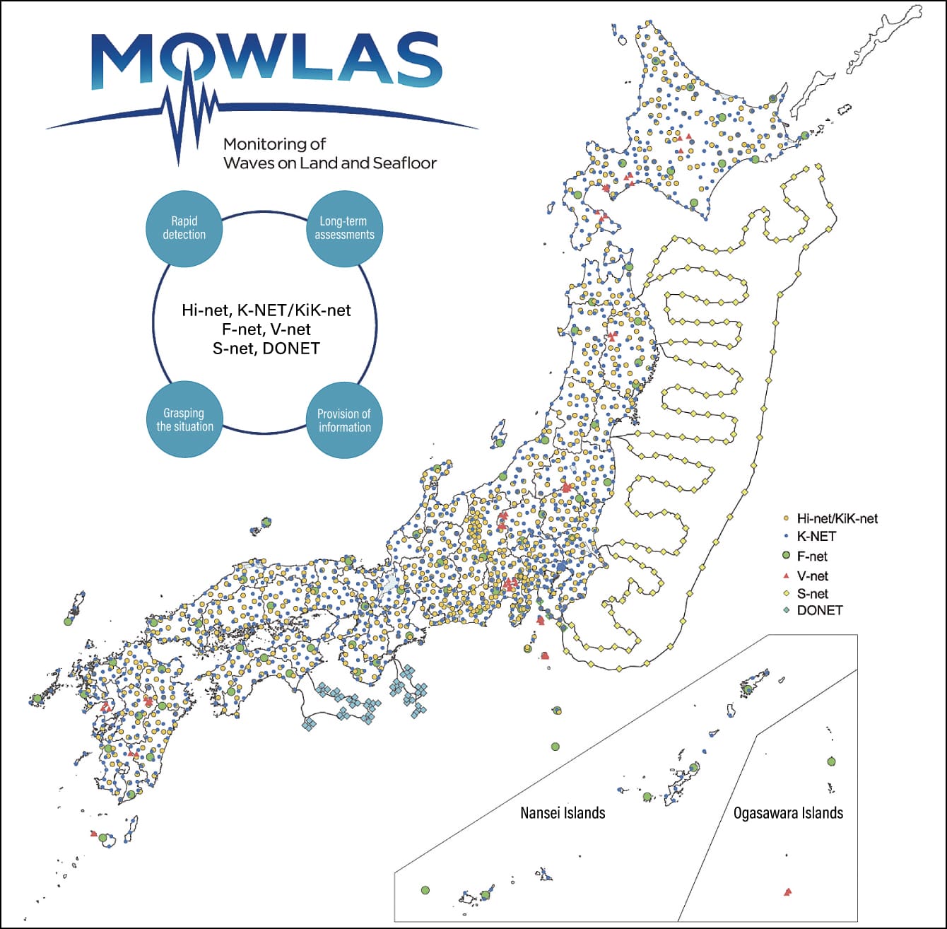 Figure courtesy of NIED
Figure 1. MOWLAS observation pointsIn addition to building and operating the MOWLAS network covering land and sea nationwide, NIED conducts research using the observation data obtained from MOWLAS.
Just now (around 13:09 on October 27, 2022), a magnitude (M) 3.7 felt earthquake (with a maximum seismic intensity of 2) occurred in the Chubu region (northern Mie Prefecture). Red concentric circles spreading out on the map on my electronic display indicate how the earthquake tremors were transmitted. White circles indicate earthquakes that have occurred within the last 24 hours. Plus-signs indicate earthquakes that occurred within the last month. Newer earthquakes are indicated in white, with the symbols becoming grayer the older the earthquakes are.
On another display beside it, a waveform graph shows earthquake tremors as time passes. It provides a real-time display of nationwide data updated every second, showing data for the last 10 minutes on a single screen.
Earthquakes occur constantly in Japan
The data transmitted to the National Research Institute for Earth Science and Disaster Resilience (NIED) each day contains details of around 500 earthquakes, which means we accumulate data on anywhere between 150,000 and 200,000 earthquakes each year. When earthquakes that we do not physically feel are included, it would be fair to say that earthquakes occur constantly in Japan.
Until the Hyogo-ken Nanbu Earthquake (Great Hanshin-Awaji Earthquake) on January 17, 1995, one of the main topics of Japanese earthquake research was the short-term prediction of earthquakes, focusing on predicting earthquakes a week or a day before they actually struck. At the time, there was something called the “Tokai earthquake hypothesis,” which held that an earthquake that would have a major impact on society was likely to occur in the Tokai region. Considerable observational resources were poured into predicting this earthquake, particularly in the Tokai region. Naturally, seismologists did not think that no earthquakes would occur outside the Tokai region, but the outcome was that the Great Hanshin-Awaji Earthquake caused a huge amount of damage. More than 6,400 people lost their lives due to the Hyogo-ken Nanbu Earthquake, which occurred outside the region designated as being affected by a Tokai earthquake. This earthquake was reported with a maximum seismic intensity of 7, but the government was unable to grasp this fact in the immediate aftermath and it took anywhere from several hours to half a day to gain an overview of the extent of the disaster, resulting in a very serious social issue.
Based on the lessons learned from that disaster, approaches to earthquake research were revised and the Headquarters for Earthquake Research Promotion (HERP) was established in accordance with the Act on Special Measures for Earthquake Disaster Countermeasures. Under the fundamental earthquake survey and observation plans formulated by HERP, NIED took charge of seismic observation. At the time, the Director-General of the Science and Technology Agency served as Director of HERP, so the body’s first director was Member of the House of Representatives, Makiko Tanaka. The Science and Technology Agency subsequently merged with the Ministry of Education, Science, Sports and Culture to form the Ministry of Education, Culture, Sports, Science and Technology (MEXT) and the current Director of HERP is MEXT Minister, Keiko Nagaoka.
An integrated observation network covering land and sea
Based on the premise that earthquakes could occur anywhere in Japan in due course, we have put in place an observation network providing uniform coverage of the entire nation, rather than undertaking selective observation of specific areas. The purpose of observation is to mitigate the damage caused by earthquakes and shed light on seismic phenomena. More specifically, it has the following four goals:
| 1) | To assess the long-term potential for earthquakes to strike |
|---|---|
| 2) | To understand and assess the current state of crustal activity |
| 3) | To upgrade seismic motion and tsunami forecasts (hazard maps) |
| 4) | To promptly transmit earthquake information such as Earthquake Early Warnings. |
NIED has put in place the five land observation networks outlined below and carries out observation at more than 1,900 sites.
High Sensitivity Seismograph Network Japan (Hi-net) observes even very small earthquakes whose tremors cannot be felt. It consists of nearly 800 stations across the country, with an average spacing of 20 km.
Kyoshin Network (K-NET) is a strong-motion seismograph network whose seismometers stay on scale even during strong shaking and are also used as seismic intensity meters. It consists of around 1,000 stations across the country, with an average spacing of 20 km.
Kiban Kyoshin Network (KiK-net) uses strong-motion seismographs installed not only on the ground surface, but also in boreholes in the earth, which helps to shed light on the impact of bedrock on powerful tremors. It is deployed at the same stations as Hi-net.
Full Range Seismograph Network of Japan (F-net) is a broadband seismic observation network capable of capturing even long-period ground motion. A total of 73 F-net stations have been installed nationwide.
In addition to these networks, there is The Fundamental Volcano Observation Network (V-net), which observes volcanic activity at 55 observation points across 16 volcanoes. Land-based observation by NIED uses seismographs, strong-motion seismographs, and tiltmeters. In addition to these, a Global Navigation Satellite System (GNSS) is used to observe crustal movement for the purpose of volcano observation, enabling scientists to identify changes in the distances between two points caused by swelling of the volcano as magma ascends.
Observation at roughly the level we are able to conduct now has been possible on land since around the early 2000s. However, the 2011 off the Pacific coast of Tohoku Earthquake (Great East Japan Earthquake) struck on March 11, 2011, causing a great deal of damage due to not only its powerful tremors, but also the huge tsunami it triggered. The seismic intensity of this earthquake registered as 5-lower or above (the highest was 7 in Kurihara City, Miyagi Prefecture) across a wide area, including the Kanto region. Fatalities and missing persons numbered in excess of 20,000 people, while more than 400,000 homes were completely or half destroyed (according to a Fire and Disaster Management Agency investigation), but most of the damage was actually caused by the massive tsunami triggered by the quake that struck East Japan’s Pacific coast.
The Japan Meteorological Agency (JMA) had set a target of issuing a tsunami warning within three minutes. The catalyst for this target was a tsunami triggered by the 1993 Hokkaido Nansei-Oki Earthquake (M7.8), resulting in 202 fatalities and 28 missing persons on Hokkaido’s Okushiri Island. At that time, it was reported the tsunami arrived three minutes after the earthquake struck.
Observation equipment measured a large tsunami 20 km offshore
The JMA did manage to issue a tsunami warning three minutes after the off the Pacific coast of Tohoku Earthquake struck. However, although the quake had a magnitude of 9.0, observations immediately afterward resulted in its being assessed as M7.9. While the numerical difference between M9.0 and M7.9 is just 1.1, the former involves approximately 40 times more energy than the latter. The initial tsunami warning gave the wave height as 1-6 m, but it was updated 28 minutes later to between 3 and more than 10 m —— more than double the original height. A massive tsunami causing major damage did, in fact, occur, and the JMA was able to update the tsunami warning 28 minutes later because buoy-style observation equipment (Ministry of Land, Infrastructure, Transport and Tourism (MLIT) GPS buoys) moored about 20 km offshore measured a large tsunami. Due to such issues as the fact that widespread power outages had already occurred by the time the tsunami warning was updated, the information did not reach the people who needed it —— this is said to be one reason why the number of human casualties was so high. This disaster provoked renewed awareness of the reality that estimating tsunami using onshore seismic observation data alone is difficult in terms not only of accuracy, but also of time.
Based on these lessons, the government decided to build the Seafloor observation network for earthquakes and tsunamis along the Japan Trench (S-net), with NIED carrying out its installation. Principally focused on the Pacific coast of the Tohoku region, S-net is an ocean bottom observation network consisting of 150 observation units linked by submarine cables measuring a total length of around 5,500 km and running from the waters off Hokkaido to those off Chiba Prefecture’s Boso Peninsula. It is one of the world’s largest observation networks capable of observing earthquakes and tsunami in the ocean in real time.
S-net uses seismometers to measure seafloor tremors and water pressure gauges to measure tsunami. When a tsunami passes over a water pressure gauge, the sea’s depth changes, which alters the water pressure and enables the water pressure gauge to be used to measure the tsunami. Pressure-resistant metal cases measuring just over 2 m long and containing observation equipment are linked like a string of pearls by means of submarine cables and continuously transmit observation data around the clock to the land stations to which they are connected. There is basically one land station at each end of the submarine cables, with two-way data transmission ensuring that even if a cable is severed by a submarine landslide or other event caused by a major earthquake, the remaining submarine cables can still be used to receive observation data. The cable-laying ships used for laying telecommunications cables are also used to install observation equipment and lay the submarine cables connecting the units. When laying cables in waters shallower than 1,500 m, a trench about 1 m deep is dug for the observation unit and submarine cable, to minimize the impact on trawling and other forms of fisheries (Figure 2).
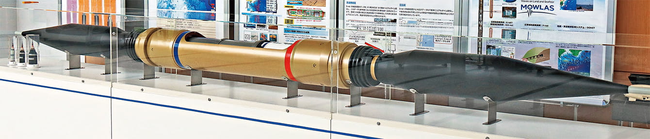
Model of ocean bottom seismograph installed in Sagami Bay.
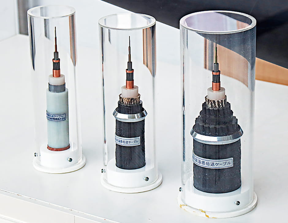
Submarine cables used in the seafloor observation network.
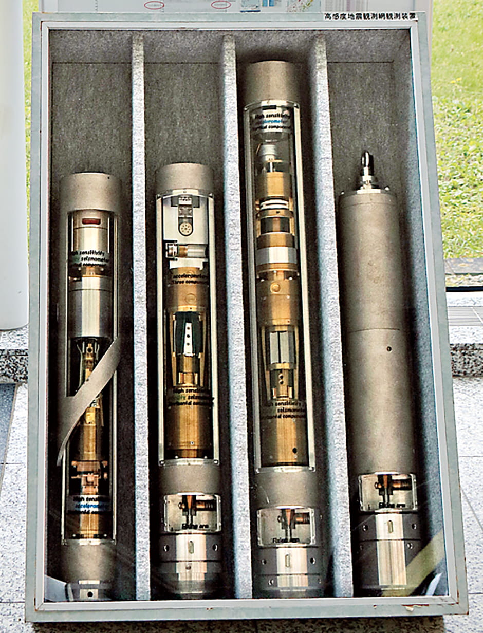
Hi-net observation units.
Figure 2. Equipment used in NIED’s earthquake and tsunami observation network
It is feared that, in the near future, a megaquake will occur along the Nankai Trough, triggering earthquakes and tsunami that will cause tremendous damage. The JMA conducts monitoring with the aid of the Tonankai submarine cable seismic observation system that it installed between the waters off Omaezaki in Shizuoka Prefecture and the waters off the Shima Peninsula in Mie Prefecture. In addition, the Dense Oceanfloor Network System for Earthquakes and Tsunamis (DONET) has been built in waters to the west of the Tonankai system. Consisting of a total of 51 observation points, DONET is divided into DONET1, which observes the offshore area of the Kumanonada Sea, and DONET2, which observes the offshore waters from the Kii Strait to the Cape Muroto.
Transmitting Earthquake Early Warnings and seismic intensity information immediately after a quake
NIED integrated these seven observation networks covering land and sea nationwide into the MOWLAS network, which went into full-scale operation in November 2017. MOWLAS has more than 2,100 observation points, covering the entire country. It takes time to forward the data to the JMA once it has been amassed at NIED. Accordingly, EarthLAN —— a network specializing in seismic observation —— has been built on an internet protocol virtual private network (IP-VPN), enabling data to be transmitted simultaneously and directly not only to NIED in Tsukuba City, Ibaraki Prefecture, but also to the JMA’s headquarters in Tokyo and its Osaka Regional Headquarters. In addition to transmitting the data to universities, research institutes, local governments, museums, and railway operators, among others, we publish the observation data on the internet for the whole world to see.
In Japan, if an earthquake with a maximum seismic intensity of 5-lower or above is forecast, the JMA issues Earthquake Early Warning alerts to areas where the seismic intensity is forecast to be 4 or higher. These alerts are carried on television and radio, and are also delivered via smartphones. In addition, seismic intensity information for the whole country is displayed on televisions within about a minute and a half of an earthquake striking. It would probably be fair to say that Japan is the only country in the world that provides such detailed information covering the entire nation. From February 1, 2023, the JMA plans also to issue information about long-period ground motion in its Earthquake Early Warnings, in addition to the conventional information about seismic intensity.
The western region of DONET, from off Kochi Prefecture to the Hyuga-Nada, are currently a blank area when it comes to earthquake and tsunami observation coverage. NIED is currently moving forward with efforts to develop and install a system in this area to create the Nankai Trough Seafloor Observation Network for Earthquakes and Tsunamis (N-net; Figure 3).
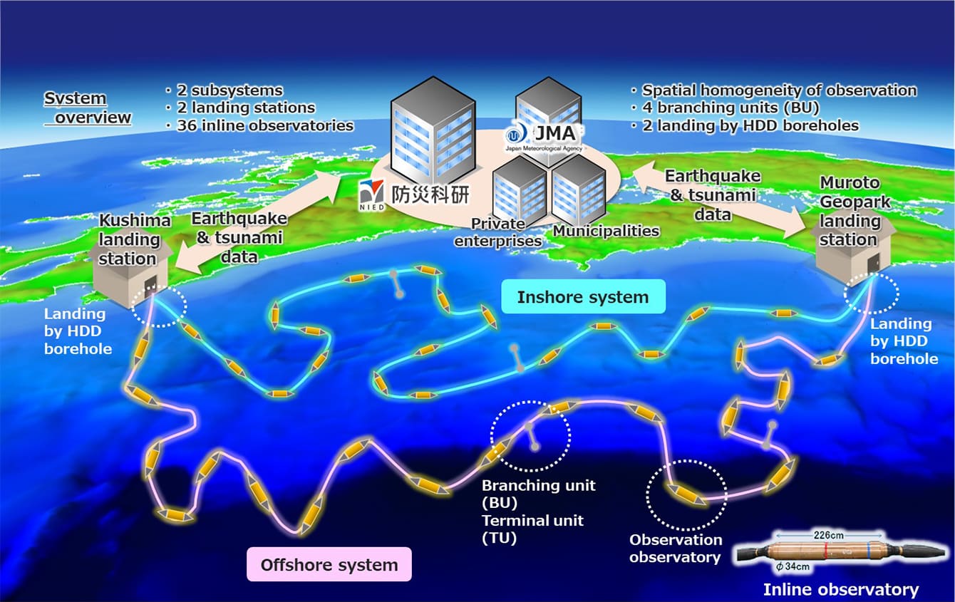 Figure courtesy of NIED
Figure 3. Illustration of the N-netBuilding the N-net will contribute to mitigating earthquake and tsunami disasters by making real-time prediction of seismic motion and tsunami faster and more accurate, and also by shedding light on earthquake and tsunami phenomena.