Major floods are becoming a frequent occurrence across the globe. Even in Japan, floods and landslides occur across the country. Accurate information is essential to ensure that people take appropriate action to evacuate in an emergency. Various kinds of reliable information about disaster risk reduction can be obtained via the mass media and online, including the KIKIKURU real-time hazard map provided by the Japan Meteorological Agency (JMA). You can also gain an understanding of the risks around you beforehand by viewing the hazard maps published by local governments. To ensure appropriate action, the most crucial thing is to make comprehensive use of the available information.
Special Feature 1 – Recommendations for Scientific Disaster Risk Reduction Floods and landslides on the rise:
How to use information to ensure appropriate action
text by Toshiko Mogi

Motoyuki Ushiyama
Professor, Shizuoka University Center for Integrated Research and Education of Natural Hazards (CIREN)
Born in Nagano Prefecture in 1968. After graduating from the Department of Forest Engineering at Shinshu University's Faculty of Agriculture, he went on to complete a doctoral program administered by Gifu University's United Graduate School of Agricultural Science while based at Shinshu University. He holds a Ph.D. in agriculture from Gifu University and a Ph.D. in engineering from Kyoto University. Before taking up his current position in 2013, he served as a visiting fellow at Tokyo Metropolitan University's Department of Geography, a research assistant at Kyoto University's Disaster Prevention Research Institute, a lecturer at Tohoku University Disaster Control Research Center, an associate professor at Iwate Prefectural University's Faculty of Policy Studies and at Shizuoka University Center for Integrated Research and Education of Natural Hazards. His field of specialism is disaster information studies. Focusing primarily on storm and flood damage, his research examines such topics as the extent of human victims, the use of disaster information, and evacuation actions.
When a major storm or flood strikes, Professor Motoyuki Ushiyama of Shizuoka University Center for Integrated Research and Education of Natural Hazards (CIREN) conducts field studies focused on locations where human victims occurred. He also conducts ongoing surveys about victims (fatalities and missing persons) resulting from floods and landslides in Japan.
Floods and landslides occur in the places you expect
“One thing I really feel each time I conduct these surveys is that floods and landslides really do occur in the places you’d expect,” says Professor Ushiyama. “It would be fair to say that it’s extremely rare to see human victims of floods and landslides in unexpected places.”
So, what kind of locations are the places where you would expect to see human victims occur as a result of floods or landslides?
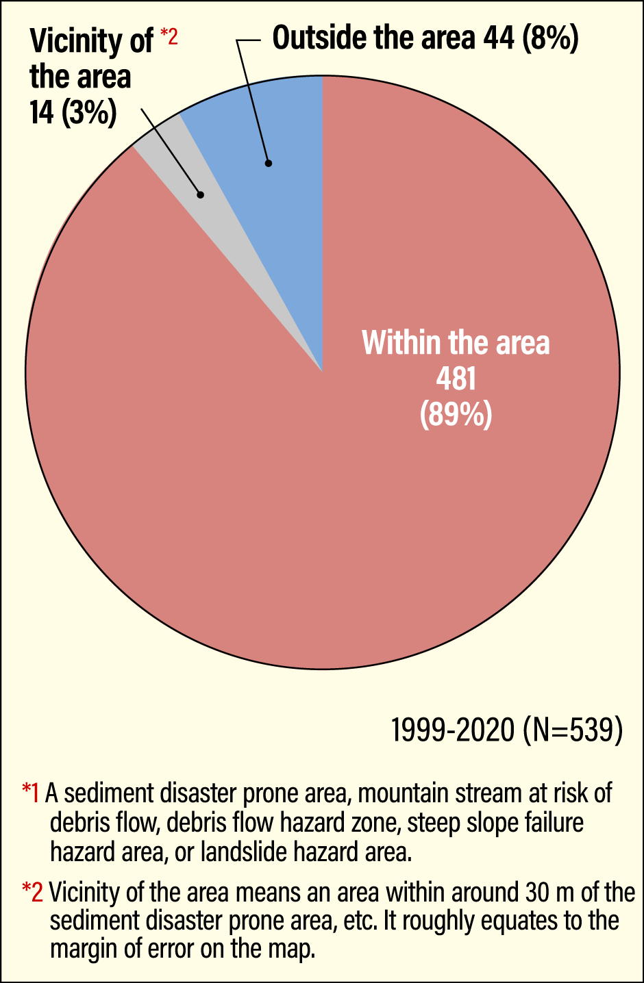
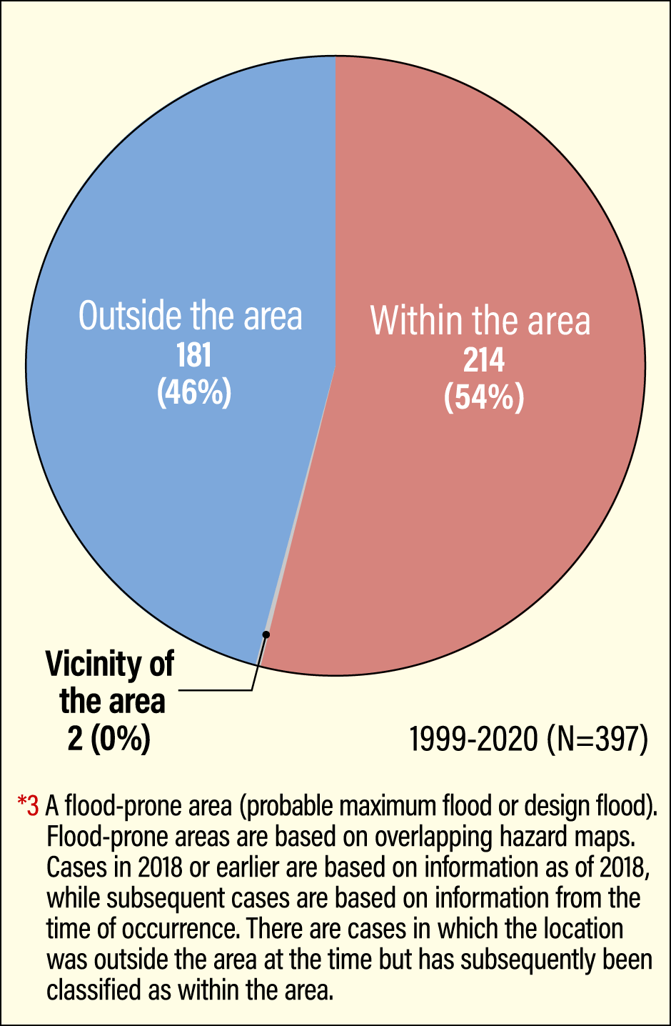
“The places where you’d expect landslides to occur are basically the highlighted areas on hazard maps. According to the results of my surveys, about 90% of the victims of landslides occurred in or near a sediment disaster prone area indicated on a hazard map,” says Ushiyama (Figure 1).
 Survey by the Ushiyama Laboratory, CIREN
Figure 1. The relationship between the locations of landslide victims and sediment disaster prone areas, etc.*192% of landslide victims between 1999 and 2020 were killed either within or in the vicinity of a sediment disaster prone area, etc.
Hazard maps are maps that show projections of where and what kind of hazards are likely to occur in the event of a natural disaster. They are drawn up and published by local governments and the like for each type of hazard, with the intention that they should be used to reduce harm and guide disaster risk reduction measures.
However, over-reliance on hazard maps is dangerous. Ushiyama took pains to emphasize that landslides do not only occur in the highlighted areas on hazard maps.
“A typical example of a place where you must take great care is on roads through mountainous areas. There are roads that run beside cliffs, or near rivers, or cross mountain streams. Japan has many such roads, but not all of them are highlighted on hazard maps.”
Why is this?
“It’s because the focus of the designation of sediment disaster prone areas and the like are basically inhabited areas. Accordingly, even if an area is topographically likely to see a landslide, it won’t be highlighted on a hazard map if it’s not inhabited.”
Ushiyama warns that roads through mountainous areas that run along steep slopes or near mountain streams with a risk of debris flows must not be considered to be safe just because they are not highlighted on a hazard map.
Underestimating small rivers could be dangerous
In the case of flooding, on the other hand, more than 50% of disaster victims who died of water-related causes (including both victims of the flood itself and those who died after falling near a swollen river) occurred near an area marked on a hazard map as a flood-prone area (Figure 2).
 Surveys by the Ushiyama Laboratory, CIREN
Figure 2. The relationship between the locations of flood and river victims and flood-prone areas*354% of flood and river victims between 1999 and 2020 occurred either within or in the vicinity of a flood-prone area.
“The designation of flood-prone areas indicated on hazard maps has principally focused on major rivers, so work on designating flood-prone areas has been completed for almost all large rivers managed at the national level. The same cannot yet be said about medium and small rivers managed by prefectural governments. You mustn’t judge a river to be safe just because it’s not highlighted on a hazard map or isn’t a large river.”
Ushiyama says places prone to flooding have certain topographical characteristics.
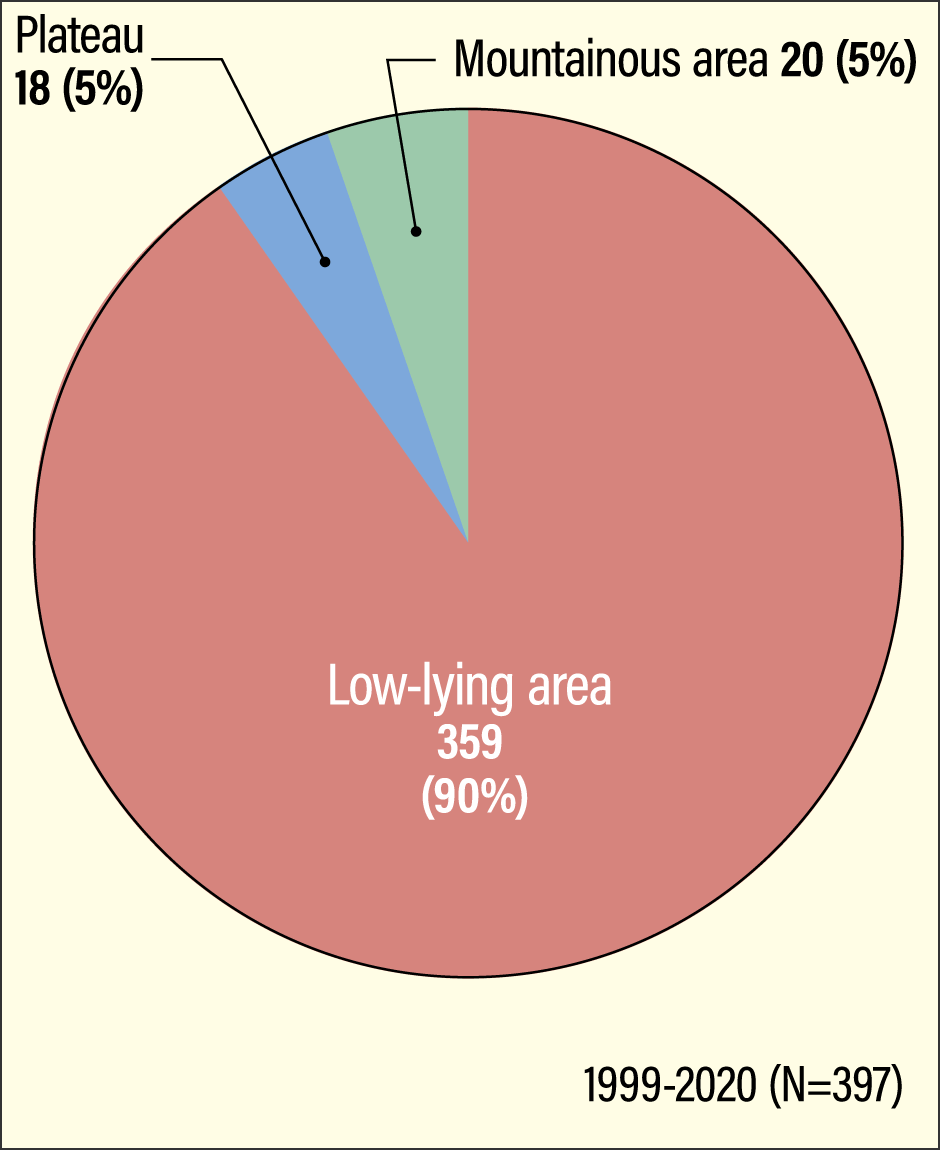
“Terrain can be broadly classified into mountainous areas, low-lying areas, and plateaus. Of these three categories, low-lying areas have a likelihood of flooding. In fact, when I investigated the relationship between the locations of water-related victims and the topography of those areas, I found that around 90% of victims had occurred in low-lying areas,” he says (Figure 3).
 Surveys by the Ushiyama Laboratory, CIREN
Figure 3. The relationship between the locations of flood and river victims and topography90% of flood and river victims between 1999 and 2020 occurred in low-lying areas with topographic potential for flooding.
Topographically speaking, the term “low-lying areas” does not refer to their altitude; rather, it denotes flat land whose height does not differ much from the height of the river. Moreover, height of the river refers not to the height of the water’s surface under normal circumstances, but to the height when the river is swollen.
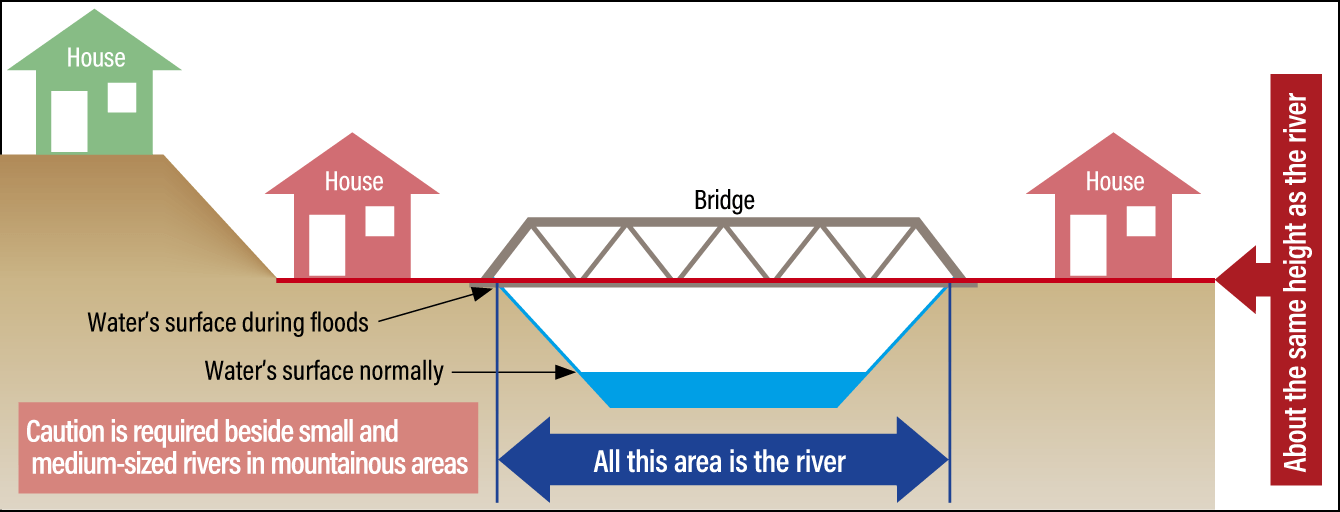
“Low-lying areas are places where floods can occur, and the terrain there is still shaped by river water even now. In addition, many low-lying areas are inhabited. People should understand that areas at about the same height as a river can be affected by floods, even if not highlighted on a hazard map,” says Ushiyama (Figure 4).
 Surveys by the Ushiyama Laboratory, CIREN
Figure 4. Areas about the same height as the river have the potential to be floodedThe term “low-lying area” of the kind prone to flooding refers to areas about the same height as the river, as shown in the diagram. Such low-lying areas are prone to being affected by floods, even if they are not indicated on hazard maps as flood-prone areas. It is necessary to understand that small and medium-sized rivers without embankments and the like pose a particular risk.
When danger from the likes of a flood or landslide is imminent, the action to take to protect life and limb from such natural disasters is evacuation.
There are various forms of evacuation actions that can be taken. The act of distancing oneself from a place where there is a risk of disaster and moving to a place of safety is what is most commonly understood by the term “evacuation.” And the first thing that comes to mind as the place to which people evacuate under these circumstances is an evacuation shelter.
“It’s actually a misconception that taking evacuation actions means going to an evacuation shelter. Going to an evacuation shelter is just one means of evacuation.”
Among the cases Ushiyama has investigated so far were some in which people lost their lives while evacuating or even at the place to which they evacuated.
“When torrential rain struck Sayo Town in Hyogo Prefecture, at night on August 9, 2009, 20 people in the town lost their lives or went missing. In fact, 12 of those people came to harm while heading for an evacuation site. Partly because of cases like this, experts started to say that going to an evacuation shelter is not the only appropriate evacuation action.”
Evacuating from a dangerous place remains a basic principle
Along with designated emergency evacuation sites specified by municipalities, Cabinet Office guidelines mention that people can evacuate to an independent evacuation site in a safe area, such as the home of a relative or friend, or a hotel or Japanese inn. In particular, since the COVID-19 pandemic began, the need to prevent the spread of infection has also become a consideration, and Ushiyama says, that approaches to evacuation other than going to an evacuation shelter have become more widely accepted as a result.
However, it is not the case that all accommodation facilities are safe. As a result of the torrential rain brought by Typhoon Talas in September 2022, a spa in Aoi Ward in Shizuoka City was struck by floods and a landslide, and staff and guests had to be rescued by the city’s firefighting helicopter.
“It’s very important to use hazard maps and other sources to check beforehand whether the place to which you intend to evacuate is safe. The other thing is that accommodation facilities aren’t free of charge.”
Even if you do not evacuate elsewhere, there are cases in which you can ensure your safety by moving to or staying on an upper floor of a building. Actions of this kind are referred to as sheltering indoors.
“In places with a risk of landslides, evacuating from that place remains a basic principle. Within flood-prone areas, certain locations are deemed to be areas with a risk of building collapse due to flooding. Given the risk of buildings being washed away or collapsing in the event of a flood, the fundamental principle in such areas is to evacuate from the area. At the same time, even where there is a possibility of flooding, for those who live in a condominium or other tall building, or in cases where the flooding is not expected to be very deep, sheltering indoors is considered to be one of the possible evacuation actions. However, in that situation, it’s necessary to make preparations ahead of time by checking the expected depth of flooding near the building and ensuring that you can manage for several days if the building becomes enclosed by the floods.”
Landslides occur in mountainous areas, while floods occur near rivers and in low-lying areas. Giving a wide berth to places with a risk of such disasters when bad weather is expected is another kind of evacuation action. In the case of landslides, there is said to be a precursory phenomenon in the form of water becoming muddy. However, Ushiyama says that it is too late to make preparations to evacuate once that phenomenon occurs.
“This kind of phenomenon indicates that earth and sand are starting to move because a slope somewhere has already collapsed; in other words, it’s information showing that a disaster is already occurring. If that’s a landslide, it’s possible the debris flow will reach your location in just a matter of seconds.”
So, at what point should we start to take such evacuation actions?
“The time to begin is when the JMA holds a press conference or weather information is broadcast on TV or via other media in slots other than during the ordinary weather forecast. You should regard this as the start of a situation outside the scope of normal circumstances.”
You can be swept away by water less than 50 cm deep
Appropriate timing and judgment are essential when taking evacuation actions after a situation outside the scope of normal circumstances has begun. Awareness of the risks of each location and information gathering are helpful in such situations.
“At the risk of repeating myself, the most fundamental element of being aware of risks is to stay away from places with a risk of flooding or landslides. This is because, as I said before, the results of my research show that around 90% of victims of floods and landslides occur in places where such disasters are likely.”
One should at all costs avoid doing things such as piling up sandbags around one’s house once the weather has deteriorated or going to look at the situation in fields or nearby rivers. One should also refrain from traveling elsewhere, whether on foot or by car, once the rain gets heavier and the flooding begins. One can apparently be swept away more easily than one might imagine.
“Disaster risk reduction pamphlets and other sources of information often contain the statement ‘you’ll be washed away once the depth of the water exceeds 50 cm,’ but I’m concerned that this wording is misleading. Whether or not you’ll be washed away depends on a combination of the water’s depth and flow velocity. You can still be washed away by water shallower than 50 cm if it’s fast-flowing. Individual differences are also involved, such as physique and strength.”
In the case of motor vehicles, a flood just 30 cm deep is enough to cause the engine to stall and render the vehicle inoperable. Once a car begins to float in the water, there is no way of controlling it. In such situations, there is a strong likelihood that a severe flood is flowing through the surrounding area, so even if the people inside the car can escape from it, they will be swept away by the flood.
“Both people and vehicles must stay out of flowing water. There’s no need to try to battle through the water to get to an evacuation shelter. You must stay away from the water. Water flows to low-lying places, so please flee to somewhere even a little higher.”
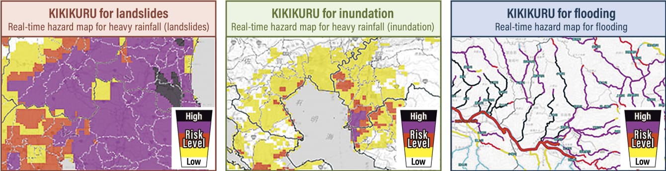
Once a situation outside the scope of normal circumstances has begun, it is vital to make full use of a number of different sources of weather information; Ushiyama recommends the JMA’s KIKIKURU tools as a useful means of gathering such information (Figure 5).
 Source: JMA website
Figure 5. Examples of KIKIKURU (Risk Level Distribution)KIKIKURU is a free website providing real-time hazard maps published by the JMA. You can access the official website by searching for KIKIKURU using a search engine on your smartphone or computer.
“The KIKIKURU pages for flood and landslide information on the JMA website use different colors to indicate the risk of things like floods and landslides on a map in real time. The amount of rainfall is often mentioned in media reports, but there are extremely large variations between regions in terms of the amount of rainfall likely to cause a disaster, so it’s difficult to interpret the risk from rainfall quantity alone.”
In the event of bad weather expected to trigger a natural disaster, municipalities issue evacuation information. In the wake of disasters, there have been times when people have criticized the slow speed at which such information is issued. However, as situations can change suddenly, there are cases in which it is not possible to avoid coming to harm by passively waiting for evacuation information.
Under the Curriculum Guideline issued by the Ministry of Education, Culture, Sports, Science and Technology, everyone from elementary to high school students is taught about safety, including disaster risk reduction. Apparently, questions about disasters and disaster risk reduction also frequently appear in the geography paper that forms part of the Common Test for University Admissions. Mechanisms that provide disaster risk reduction information are also improving dramatically, including information provided via mass media, the internet, and various apps.
“The JMA is striving to provide highly accurate forecasts, while municipalities are also doing their best to issue appropriate evacuation information. However, they can’t issue behavioral instructions telling each and every individual citizen what they should do. It is vital for each of us to identify the risks around us and to use information effectively to take appropriate action.”
(Figures courtesy of Motoyuki Ushiyama)